Instrumentation and hardware was a bit crude but I'm satisfied that I know a bit more about effects of antenna mounting slope than I did this morning. For whatever reason, I was of the impression that AOR-W is on the Galaxy 5 bird. Online info says that should be 207° azimuth from here and 31° elevation. I parked the tractor in the open at a heading of 207°. Horizon to the W, S, & E is clear of trees and powerlines as the first pic shows. My adjustable angle mount was made from a camera tripod with a 16" diameter steel sheet bolted to it. The magnetic angle finder was used to determine slope of the makeshift mounting plane. The antenna was mounted in the middle of the steel circle. Samples were observed at roughly 2 minute intervals. The Diff. SNR fluctuated so I observed and noted the range it moved through during the intervals. # of satellites stayed fairly constant during the sample interval, as did the HDOP. Here's the small data sample: | UTC | Ant | # Sats. | HDOP | Diff. SNR | | | Slope | | | Max | Min | | 17:54 | 0 | 10 | 1.1 | 39.0 | 38.1 | | 18:00 | 0 | 11 | 0.8 | 39.1 | 38.1 | | 18:03 | -10 | 10 | 0.9 | 35.9 | 34.0 | | 18:05 | -10 | 10 | 0.9 | 35.9 | 34.7 | | 18:07 | -20 | 9 | 1.1 | 35.7 | 32.9 | | 18:10 | -20 | 9 | 0.9 | 36.0 | 33.9 | | 18:13 | -30 | 10 | 0.8 | 34.3 | 33.5 | | 18:15 | -30 | 10 | 0.8 | 34.6 | 33.1 | | 18:18 | -40 | 8 | 1.0 | 34.9 | 33.1 | | 18:20 | -40 | 7 | 1.2 | 35.2 | 33.7 | | 18:24 | -40 | 8 | 1.0 | 34.3 | 33.1 | | 18:26 | 0 | 10 | 0.8 | 39.0 | 37.5 | | 18:28 | 0 | 11 | 0.8 | 38.4 | 36.7 | | 18:30 | -15 | 11 | 0.8 | 35.7 | 34.2 | | 18:32 | -30 | 9 | 0.9 | 34.7 | 33.7 | | 18:34 | -43 | 10 | 0.8 | 35.2 | 33.3 | | 18:36 | 10 | 11 | 0.8 | 39.3 | 38.5 | | 18:38 | 10 | 11 | 0.8 | 40.6 | 39.8 | | 18:40 | 20 | 10 | 0.8 | 42.0 | 40.8 | | 18:42 | 0 | 11 | 0.8 | 38.5 | 35.7 | | 18:44 | 0 | 10 | 0.8 | 38.5 | 35.7 | | 18:46 | -20 | 10 | 0.8 | 36.5 | 34.4 | | 18:48 | -20 | 10 | 0.8 | 37.3 | 35.9 | | 18:50 | 0 | 10 | 0.8 | 39.9 | 38.5 | | 18:52 | 0 | 10 | 0.8 | 40.7 | 38.9 | | 18:56 | -30 | 8 | 1.0 | 35.0 | 33.7 |
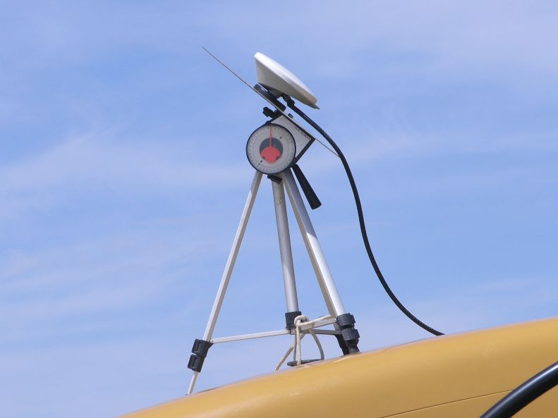
Negative elevation values denote higher elevation for the front of the plate. 0 is horizontal and positive values denote nose down position for the plate. Pics of horizon, tripod mount, and angle settings.
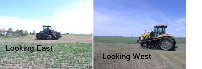 (horizons.JPG) (horizons.JPG)
 (tripod1.jpg) (tripod1.jpg)
 (43 degrees.jpg) (43 degrees.jpg)
Attachments
----------------
 horizons.JPG (38KB - 1167 downloads) horizons.JPG (38KB - 1167 downloads)
tripod1.jpg (43KB - 1174 downloads)
43 degrees.jpg (33KB - 1153 downloads)
|  Like a homesick angel

